Population et densité
—
publié le 16 juillet 2019
(2019)
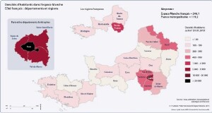
France : recensement 2016 et estimations de population 2019
Population municipale (nombre et évolution), densité (2016-2019)
| FRANCE | Statut administratif | Superficie (km²) | Population 01/01/2016 | Part de la pop. régionale 2016 | Part pop. / France métro 2016 | Population 01/01/2019 (est.) | Évolution (%) 2016-2019 | Densité (hab. par km²) 2016 | Densité (hab. par km²) 2019 |
| Nord | Département | 5 742,8 | 2 603 723 | 43,3 % | 4,0 % | 2 592 185 | - 0,4 | 453,4 | 451,4 |
| Pas-de-Calais | Département | 6 671,4 | 1 470 725 | 24,5 % | 2,3 % | 1 463 196 | - 0,5 | 220,5 | 219,3 |
| Aisne | Département | 7 369,1 | 536 136 | 8,9 % | 0,8 % | 528 016 | - 1,5 | 72,8 | 71,7 |
| Oise | Département | 5 860,2 | 823 542 | 13,7 % | 1,3 % | 825 207 | + 0,2 | 140,5 | 140,8 |
| Somme | Département | 6 170,1 | 572 744 | 9,5 % | 0,9 % | 569 662 | - 0,5 | 92,8 | 92,3 |
| Total Hauts-de-France | Région | 31 814 | 6 006 870 | 9,3 % | 5 978 266 | - 0,5 | 188,8 | 187,9 | |
| Eure | Département | 6 039,9 | 602 825 | 18,1 % | 0,9 % | 606 419 | + 0,6 | 99,8 | 100,4 |
| Seine-Maritime | Département | 6 277,6 | 1 255 755 | 37,6 % | 1,9 % | 1 248 590 | - 0,6 | 200,0 | 198,9 |
| Calvados | Département | 5 547,9 | 693 679 | 20,8 % | 1,1 % | 691 676 | - 0,3 | 125,0 | 124,7 |
| Manche | Département | 5 938,0 | 498 362 | 14,9 % | 0,8 % | 492 627 | - 1,2 | 83,9 | 83,0 |
| Orne | Département | 6 103,4 | 285 308 | 8,6 % | 0,4 % | 279 755 | - 1,9 | 46,7 | 45,8 |
| Total Normandie | Région | 29 907 | 3 335 929 | 5,2 % | 3 319 067 | - 0,5 | 111,5 | 111,0 | |
| Côtes-d'Armor | Département | 6 877,6 | 598 953 | 18,1 % | 0,9 % | 596 518 | - 0,4 | 87,1 | 86,7 |
| Finistère | Département | 6 733,0 | 908 249 | 27,5 % | 1,4 % | 905 238 | - 0,3 | 134,9 | 134,4 |
| Ille-et-Vilaine | Département | 6 774,7 | 1 051 779 | 31,8 % | 1,6 % | 1 076 330 | + 2,3 | 155,3 | 158,9 |
| Morbihan | Département | 6 822,6 | 747 548 | 22,6 % | 1,2 % | 751 309 | + 0,5 | 109,6 | 110,1 |
| Total Bretagne | Région | 27 208 | 3 306 529 | 5,1 % | 3 329 395 | + 0,7 | 121,5 | 122,4 | |
| Paris | Département | 105,4 | 2 190 327 | 18,1 % | 3,4 % | 2 140 526 | - 2,3 | 20 781,1 | 20 308,6 |
| Seine-et-Marne | Département | 5 915,3 | 1 397 665 | 11,5 % | 2,2 % | 1 421 735 | + 1,7 | 236,3 | 240,3 |
| Yvelines | Département | 2 284,4 | 1 431 808 | 11,8 % | 2,2 % | 1 436 581 | + 0,3 | 626,8 | 628,9 |
| Essonne | Département | 1 804,4 | 1 287 330 | 10,6 % | 2,0 % | 1 314 827 | + 2,1 | 713,4 | 728,7 |
| Hauts-de-Seine | Département | 175,6 | 1 603 268 | 13,2 % | 2,5 % | 1 606 088 | + 0,2 | 9 130,2 | 9 146,3 |
| Seine-Saint-Denis | Département | 236,2 | 1 606 660 | 13,3 % | 2,5 % | 1 654 477 | + 3,0 | 6 802,1 | 7 004,6 |
| Val-de-Marne | Département | 245,0 | 1 378 151 | 11,4 % | 2,1 % | 1 395 209 | + 1,2 | 5 625,1 | 5 694,7 |
| Val-d'Oise | Département | 1 245,9 | 1 221 923 | 10,1 % | 1,9 % | 1 243 921 | + 1,8 | 980,8 | 998,4 |
| Total Île-de-France | Région | 12 012 | 12 117 132 | 18,8 % | 12 213 364 | + 0,8 | 1 008,7 | 1 016,7 | |
| Hors Île-de-France | 88 928 | 1 649 328 | 19,6 % | 12 626 728 | - 0,2 | 142,2 | 142,0 | ||
| Espace Manche | 100 941 | 24 766 460 | 38,4 % | 24 840 092 | + 0,3 | 245,4 | 246,1 | ||
| France métropolitaine | 543 940 | 64 468 792 | 64 812 052 | + 0,5 | 118,5 | 119,2 | |||
Sources : Insee, populations légales 2016, estimations de population 2019.
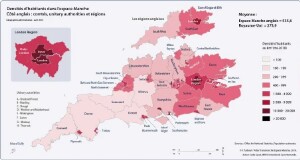
Angleterre : recensement 2011 et estimations de population 2018
Population (nombre et évolution), densité (2011-2018)
| ANGLETERRE | Statut administratif* 2015 | Superficie (km²) | Population 2011 | Part de la pop. régionale 2011 | Part pop. / Royaume-Uni 2011 | Population mi-2018 (est.) | Évolution (%) 2011-2018 | Densité (hab. par km²) 2011 | Densité (hab. par km²) 2018 |
| Bath & NE Somerset | Unitary authority | 345,5 | 176 016 | 3,3 % | 0,3 % | 192 106 | + 9,1 | 509,4 | 556,0 |
| Bournemouth | Unitary authority | 46,2 | 183 491 | 3,5 % | 0,3 % | 194 355 | + 5,9 | 3 973,5 | 4 208,7 |
| Bristol, City of | Unitary authority | 109,6 | 428 234 | 8,1 % | 0,7 % | 463 405 | + 8,2 | 3 906,9 | 4 227,7 |
| Cornwall | Unitary authority | 3 546,2 | 532 273 | 10,1 % | 0,8 % | 565 968 | + 6,3 | 150,1 | 159,6 |
| Devon | Comté | 6 564,2 | 746 399 | 14,1 % | 1,2 % | 795 286 | + 6,5 | 113,7 | 121,2 |
| Dorset | Comté | 2 541,6 | 412 905 | 7,8 % | 0,7 % | 426 516 | + 3,3 | 162,5 | 167,8 |
| Gloucestershire | Comté | 2 653,2 | 596 984 | 11,3 % | 0,9 % | 633 558 | + 6,1 | 225,0 | 238,8 |
| Isles of Scilly | Unitary authority | 16,4 | 2 203 | 0,0 % | 0,0 % | 2 242 | + 1,8 | 134,3 | 136,7 |
| North Somerset | Unitary authority | 373,8 | 202 566 | 3,8 % | 0,3 % | 213 919 | + 5,6 | 541,9 | 572,3 |
| Plymouth | Unitary authority | 79,8 | 256 384 | 4,8 % | 0,4 % | 263 100 | + 2,6 | 3 213,6 | 3 297,8 |
| Poole | Unitary authority | 64,8 | 147 645 | 2,8 % | 0,2 % | 151 397 | + 2,5 | 2 280,1 | 2 338,1 |
| Somerset | Comté | 3 450,5 | 529 972 | 10,0 % | 0,8 % | 559 399 | + 5,6 | 153,6 | 162,1 |
| South Gloucestershire | Unitary authority | 496,9 | 262 767 | 5,0 % | 0,4 % | 282 644 | + 7,6 | 528,8 | 568,8 |
| Swindon | Unitary authority | 230,1 | 209 156 | 4,0 % | 0,3 % | 221 996 | + 6,1 | 909,0 | 964,8 |
| Torbay | Unitary authority | 62,9 | 130 959 | 2,5 % | 0,2 % | 135 780 | + 3,7 | 2 082,6 | 2 159,3 |
| Wiltshire | Unitary authority | 3 255,3 | 470 981 | 8,9 % | 0,7 % | 498 064 | + 5,8 | 144,7 | 153,0 |
| Total South West | Region | 23 837 | 5 288 935 | 8,4 % | 5 599 735 |
+ 5,9
|
221,9 | 234,9 | |
| Bracknell Forest | Unitary authority | 109,4 | 113 205 | 1,3 % | 0,2 % | 121 676 | + 7,5 | 1 034,9 | 1 112,4 |
| Brighton and Hove | Unitary authority | 82,7 | 273 369 | 3,2 % | 0,4 % | 290 395 | + 6,2 | 3 306,8 | 3 512,8 |
| Buckinghamshire | Comté | 1 564,9 | 505 283 | 5,9 % | 0,8 % | 540 059 | + 6,9 | 322,9 | 345,1 |
| East Sussex | Comté | 1 708,6 | 526 671 | 6,1 % | 0,8 % | 554 590 | + 5,3 | 308,2 | 324,6 |
| Hampshire | Comté | 3 678,9 | 1 317 788 | 15,3 % | 2,1 % | 1 376 316 | + 4,4 | 358,2 | 374,1 |
| Isle of Wight | Unitary authority | 380,2 | 138 265 | 1,6 % | 0,2 % | 141 538 | + 2,4 | 363,7 | 372,3 |
| Kent | Comté | 3 543,5 | 1 463 740 | 17,0 % | 2,3 % | 1 568 623 | + 7,2 | 413,1 | 442,7 |
| Medway | Unitary authority | 192,0 | 263 925 | 3,1 % | 0,4 % | 277 855 | + 5,3 | 1 374,4 | 1 446,9 |
| Milton Keynes | Unitary authority | 308,6 | 248 821 | 2,9 % | 0,4 % | 268 607 | + 8,0 | 806,2 | 870,3 |
| Oxfordshire | Comté | 2 604,9 | 653 798 | 7,6 % | 1,0 % | 687 524 | + 5,2 | 251,0 | 263,9 |
| Portsmouth | Unitary authority | 40,4 | 205 056 | 2,4 % | 0,3 % | 215 133 | + 4,9 | 5 075,6 | 5 325,1 |
| Reading | Unitary authority | 40,4 | 155 698 | 1,8 % | 0,2 % | 163 203 | + 4,8 | 3 854,2 | 4 039,9 |
| Slough | Unitary authority | 32,5 | 140 205 | 1,6 % | 0,2 % | 149 112 | + 6,4 | 4 309,3 | 4 583,1 |
| Southampton | Unitary authority | 49,9 | 236 882 | 2,7 % | 0,4 % | 252 796 | + 6,7 | 4 747,1 | 5 066,1 |
| Surrey | Comté | 1 662,5 | 1 132 390 | 13,1 % | 1,8 % | 1 189 934 | + 5,1 | 681,1 | 715,7 |
| West Berkshire | Unitary authority | 704,2 | 153 822 | 1,8 % | 0,2 % | 158 527 | + 3,1 | 218,4 | 225,1 |
| West Sussex | Comté | 1 990,5 | 806 892 | 9,3 % | 1,3 % | 858 852 | + 6,4 | 405,4 | 431,5 |
| Windsor & Maidenhead | Unitary authority | 196,5 | 144 560 | 1,7 % | 0,2 % | 150 906 | + 4,4 | 735,6 | 767,9 |
| Wokingham | Unitary authority | 179,0 | 154 380 | 1,8 % | 0,2 % | 167 979 | + 8,8 | 862,6 | 938,6 |
| Total South East | Region | 19 070 | 8 634 750 | 13,7 % | 9 133 625 | + 5,8 | 452,8 | 479,0 | |
| Bedford | Unitary authority | 476,4 | 157 479 | 2,7 % | 0,2 % | 171 623 | + 9,0 | 330,6 | 360,2 |
| Central Bedfordshire | Unitary authority | 715,7 | 254 381 | 4,4 % | 0,4 % | 283 606 | + 11,5 | 355,4 | 396,3 |
| Essex | Comté | 3 464,4 | 1 393 587 | 23,8 % | 2,2 % | 1 477 764 | + 6,0 | 402,3 | 426,6 |
| Hertfordshire | Comté | 1 643,1 | 1 116 062 | 19,1 % | 1,8 % | 1 184 365 | + 6,1 | 679,2 | 720,8 |
| Luton | Unitary authority | 43,4 | 203 201 | 3,5 % | 0,3 % | 214 109 | + 5,4 | 4 687,2 | 4 938,8 |
| Southend-on-Sea | Unitary authority | 41,8 | 173 658 | 3,0 % | 0,3 % | 182 463 | + 5,1 | 4 158,9 | 4 369,8 |
| Thurrock | Unitary authority | 163,4 | 157 705 | 2,7 % | 0,2 % | 172 525 | + 9,4 | 965,3 | 1 056,0 |
| Total East (EM) | Area | 6 548 | 3 456 073 | 59,1 % | 5,5 % | 3 686 455 | + 6,7 | 527,8 | 563,0 |
| Total East of England | Région | 19 119 | 5 846 965 | 9,3 % | 6 201 214 | + 6,1 | 305,8 | 324,3 | |
| Inner London | London boroughs | 319,3 | 3 231 901 | 39,5 % | 5,1 % | 3 600 203 | + 11,4 | 10 121,8 | 11 275,3 |
| Outer London | London boroughs | 1 252,9 | 4 942 040 | 60,5 % | 7,8 % | 5 307 878 | + 7,4 | 3 944,5 | 4 236,5 |
| Total London | Région | 1 572 | 8 173 941 | 12,9 % | 8 908 081 | + 9,0 | 5 199,0 | 5 666,0 | |
| * Géographie administrative - avril 2015 | |||||||||
| Hors London | 49 455 | 17 379 758 | 27,5 % | 18 419 815 | + 6,0 | 351,4 | 372,5 | ||
|
Espace Manche
|
51 027 | 25 553 699 | 40,4 % | 27 327 896 | + 6,9 | 500,8 | 535,6 | ||
| Royaume-Uni | 242 545 | 63 182 178 | 66 435 550 | + 5,1 | 260,5 | 273,9 | |||
Sources : Office for National Statistics - Census 2011, Populations estimates 2018.
Note []
Pour citer ce document :
Sauvé, L. (2019). Population et densité. Atlas Transmanche.