
 Accessibility - intermodality
Speed, travelling faster, transporting faster: our societies have deployed considerable ingenuity and effort in the attempt to achieve this objective. The last century saw considerable progress. Gains in time are such that perceived space seems contracted, distance-time in Europe now being expressed in hours rather than days.
The spaces of the Channel, like those of the world in general, have undergone considerable change. The radical change in the late 20th century was the completion of the old dream of a tunnel under the Channel. Following decades of planning and a multiplicity of projects, a few years of building led to the opening of the Tunnel under the Dover strait in 1994, with a French entrance at Calais and an English exit at Folkestone. Britain was no longer absolutely insular. Passenger shuttles now link Paris to London in just over 2 hours. Lorries are loaded onto special freight trains.
For over ten years the choice between ferry and Tunnel, has introduced a new configuration to the links between the British Isles and continental destinations. The common view is that the Tunnel makes for faster passage. This is true… but only just. An analysis of links between eighty-three European cities, from Aberdeen to Algeciras, demonstrates that the reality is much more subtle.
Two matrices of links between cities have been constructed: one including passage either via the Tunnel or by sea, the shortest route in terms of time being selected; the other system involving travel systematically by sea. Over the routes for which the two modes are compared, the Tunnel route represents a gain of 10 to 15 minutes between English cities and twenty continental cities. Only Calais gains 36 minutes per journey; Antwerp, Brussels, Dunkirk, Hamburg, Rotterdam, Lille and Zeebrugge gain 15; cumulative gains for each of them total around 10 hours. For short trips and cities near the Tunnel (Benelux, southern and central England), the benefit appears to be substantial. These are the regions that stand to gain most from the use of the Tunnel. The gain drops progressively for journeys starting in Strasbourg, Turin, Rome, Metz, Milan, Arras, Besançon, Grenoble, Marseille, Lyon, Toulon and Nice. It represents a negligible part of longer journeys, less than 1.5% of the total. Over the 83 x 83 links, 300 hours (from a total 54 100 hours) may be saved.
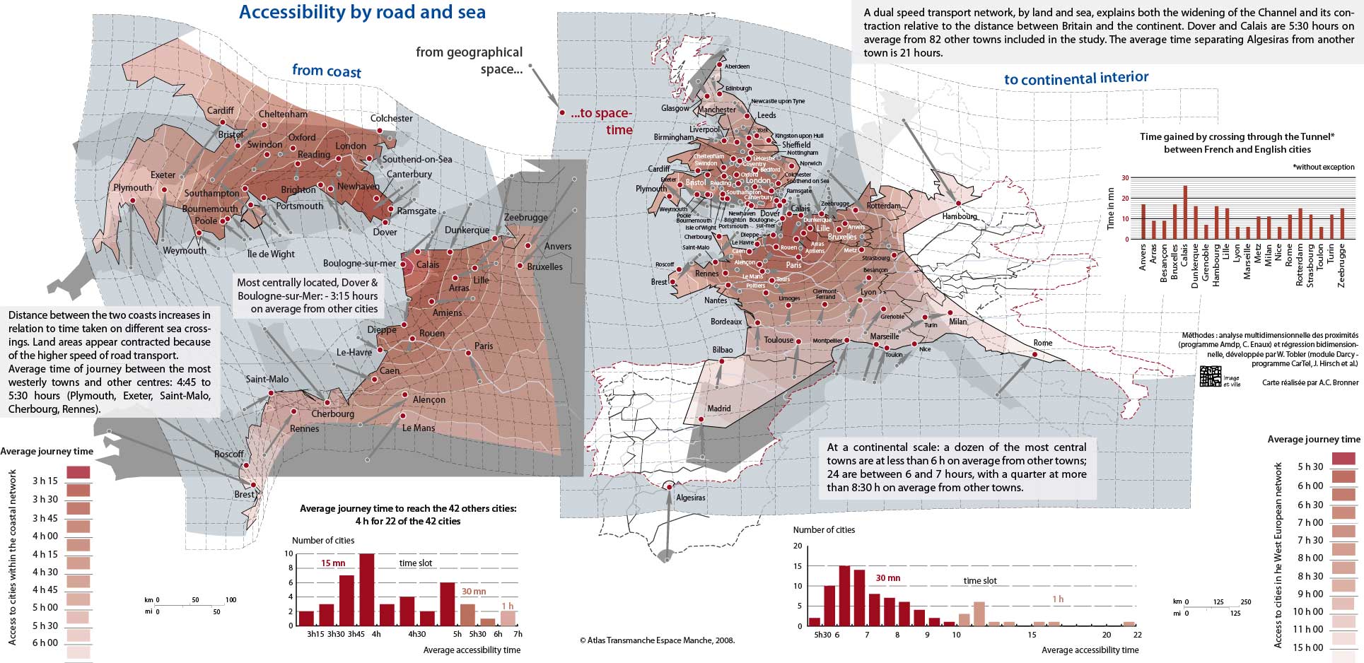
From coast to continental interior
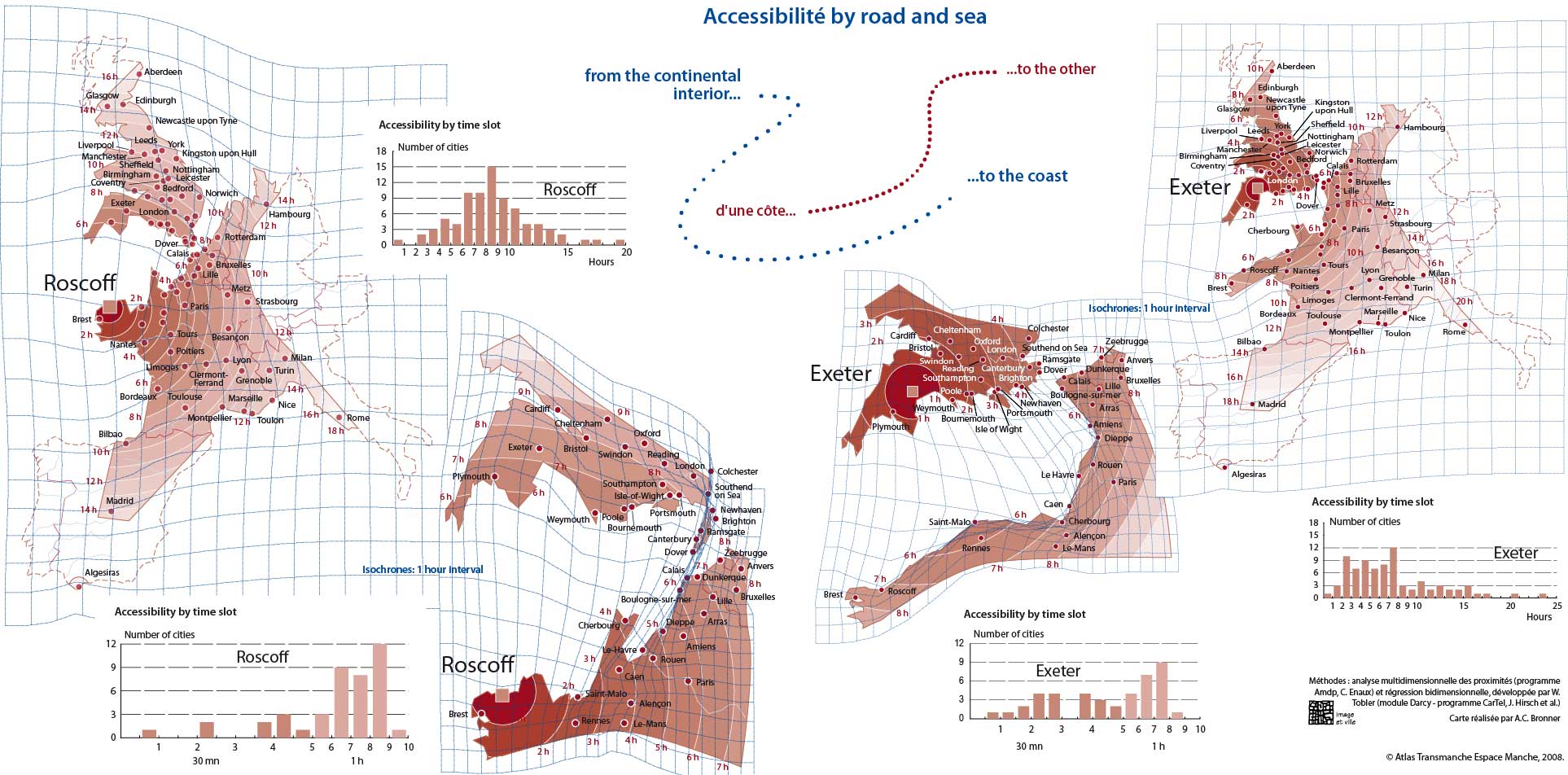
From the continental interior to the coast
The maps represent the road-ferry-road journeys, excluding passage through the Tunnel. The anamorphic representation transforms geographic space by application of the time variable. The folds in the grid represent space-time. The relative positions of the 83 cities are calculated on the basis of access time, taken simultaneously, transforming the geographical space, grey on the map, into the “contracted” or “dilated” space in the second colour, with arrows indicating the “displacement” of the cities’ positions. As the modes of transport we are considering by road and by sea, are relatively slow they lack the spectacular element of high speed links with its corresponding spatial distortion. Nevertheless, they do reveal a differentiated space. Were central Europe to be added, the relative positions, “temporal deformation” and resultant representation on a map, would change. Within the present group, the land areas are distorted, with a tendency to push Italian cities eastwards and Hamburg to the southeast. The inclusion of central Europe would probably produce greater spatial differentiation across the continent given the variable quality of the road network.
Average speed by sea remains slower than by road. This explains the presence of wide open spaces across on the map. The cities are “closer” to each other via the road and motorway route on the continent than via the maritime route. The map accentuates the time-gap between the coastal towns, dilating space by creating openings to the west. This gap should not obscure an essential element: these links may be slower but they provide useful connections between ports as well as into their hinterlands. The measure used relates to the new generation of ferries, faster, more comfortable and with a higher lorry loading capacity than their predecessors, but the high-speed seasonal links carrying less freight have not been included. The new fast links for passengers in the central Channel offer crossings of around three hours and the possibility of day returns. This situation is thus clearly relative: relative to a rapid motorway network, particularly on the continent, and relative to types of ship.
It is the route that makes the difference. The way one crosses the Channel has only a very secondary influence on the European time scale, but the repercussions and its subsequence development are as important for intra-European exchanges and environmental impact as for the economies of several sectors and of the regions in question.
Recalculated, not zoomed, for 43 cities around the Channel, the “temporal” redistribution of cities underlines the speeds of the network and sea-crossing times that dilate geographical space, and highlights the accessibility of the most central towns, whose average access time (the average journey time taken to reach the other towns in the study area) is around three and half hours.
Thus it appears that the two modes (Tunnel and ferry) are complimentary. The Tunnel diminishes space-time for regions in close proximity that are already economically powerful, but this reduction is only significant over the shortest journeys and for the most central cities. The maritime routes linking more distant cities and regions hugely offset any gain represented by the Tunnel, and offer other advantages such as rest time and variety in the journey. Their maintenance and improvement are a development issue not only for nearby regions but also for areas as distant as those of Spain or those of northern Britain. At stake is the strategic advantage for ports and their regions to exploit such mental maps so as to influence route choice by transport operators, GPS users, etc.
The Tunnel has brought certain cities “closer together,” but increased distance-time gains of the coming decades are more likely to be realised on the sea routes.
top


