
 Presentation
- Administrative geography (2019-2020)
- Coastline in figures
- Découpage administratif (2016) FR
- From Land's End to the Strait
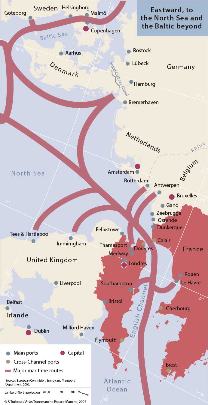
The Channel is the umbilical cord between the world and Europe, whose history and prosperity have been built around this sea. This cord does not stop at the Straits, it continues through to the North Sea – immediately on the port side the ports of the Thames Estuary and to starboard Antwerp, Rotterdam and Amsterdam, then Hamburg and Bremen. After 20 to 40 days at sea, most of the traffic stops here, but some goes on through the passage of the Skagerrak which, after encircling Denmark, leads into the Baltic en route for Oslo, Gdansk, Stockholm and Saint Petersburg to the east.
As the point of convergence of the world’s maritime traffic for several centuries, the Channel is also the sea of the two prime meridians – the Paris Meridian established in 1667 and the Greenwich in 1675, with the Greenwich Meridian internationally recognised since 1884. Both Paris and Greenwich bear witness to the growing influence of men of science – the academies, the Royal Society – and their passionate interest across the ages in measuring longitude in an attempt to gain mastery of the seas and conduct long ocean voyages. This scientific competition over successive generations testifies to the equivalent conflict between the English and French powers for international dominance.
Passage, canal, strait – the Channel is a narrow sea turned towards the world and bordered by small localities, each defined by its own strong identity and sphere of relations. These are not the “narrow seas” that Fernand Braudel describes in the Mediterranean, i.e. small sea basins, each with its dominant town, its own ways of navigation, rigging and constructing ships. In the Channel the horizons are more open, the distances shorter, the communications have long been easier and the customs shared. It was, and still is, an ensemble of local port communities, both large and small, or islands with particular identities that different spatial and temporal matrices have forged over the centuries.
More often than not, the locally specific has been the product of some dominant activity whose imprint extended well beyond any simple economic impact. Its changing geography, population make-up, trades and skills, the changing influence of corporations and social classes, the receptiveness or otherwise to different ideas, all have contributed to the creation of these local specificities. These “fabricated identities,” seen in all regions, often take on a particular resonance or amplitude in seaports and islands. Their relations with destination places, whether far or near, contribute as much to their material reality as to their imaginaries. So also, depending on the size of port, does the often greater population mix, the relationship to an hinterland very much apart, give rise to their particularity. In the case of islands, depending on their location and varying periods of social isolation, can be added their closed character and physical delimitation. Though they have been distorted, partially effaced and reconstructed across the centuries, following periods of major political and economic change, all these acquired characteristics have been organised around a framework of common components that justify talking of a maritime identity.
Neither is the Channel another Mediterranean. A “Mediterranean,” viewed conceptually by reference to the eponymous sea, is a sea where exchange is organised around basins, a ‘come and go’ circulation with contact between societies at different stages of development and different cultural systems; a sea made up of a succession of ‘liquid plains,’ sub-divisions of a much greater expanse of water. This model, found in some parts of the world, is not one that applies to the Channel.
The Channel constitutes a single maritime entity, in history largely linked to distant seas. Its main ports, whether commercial or military, were directed in their aspirations and their efforts to far-off lands. Whatever the period in question, whether that of the establishment of the great trading companies, the creation of fisheries, the equipping and supply of expeditions to the New World, the affirmation of naval military power, empire-building, the emigration to the United States, the development of the great shipping lines, the main Channel ports were drawn to the other side of the oceans, turning their backs for the most part on their respective hinterlands.
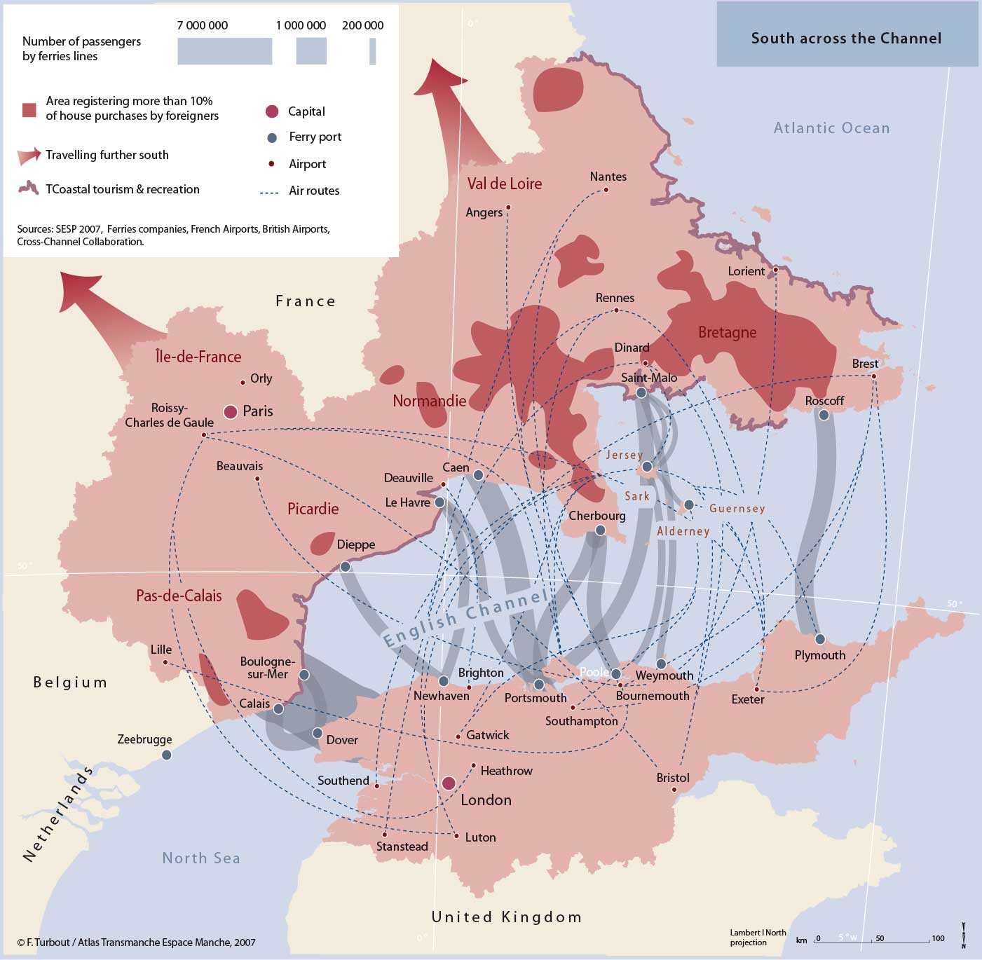
This narrow stretch of water would also become a small Franco-British sea. The exchange links between the two facing shores, and those of Ireland, go back more than two millennia. Today the British archipelago and the continent are tied together by a myriad of links. Tens of ferry routes provide a continuous cross-Channel service, totalling more than 26 million passengers and more than 4 million lorries carried annually. The old dream of a tunnel under the Channel finally saw the light of day in 1994. Far from reducing the sea-going traffic, it has stimulated new demand with increased capacity. Finally one can add the multiplication of air-links, increasing choice of routes to both larger international airports located further inland, and newly opened routes by low-cost carriers operating from much expanded coastal airports. The very ease and relative cost of such transport links have made the other side of the Channel an increasingly popular destination for British holiday-makers as well as second-home owners.
The whole combination of traffic, exchange and shared history has turned this narrow stretch of land and sea into a small world within Europe, a Franco-British ‘pond’ at the same time as a major maritime thoroughfare of world trade.
The recent growth of activity in the Channel area has been considerable, as much on the sea as along its shores. The level of frequency and intensity has proved unceasing. Considerable pressure has impacted on the environment, a difficult accommodation of competing uses, at a time of considerable potential human and economic development.
A new form of transfrontier space has thus emerged, but where the reality of exchanges and problems in common has largely transcended a little-developed public consciousness. The strong identities of the local regions encompassed by the two large nation-states prevailed, but the traumatic events of the 20th century, followed by a growing proximity built on leisure-related travel, have brought them closer together. Today’s context, that of the European Union and the accentuation of a far-reaching globalisation, opens up the possibility of a new future, that of a transfrontier region, an internal sea within Europe, where a sense of belonging and linked destiny will create its own dynamic; a vision which will achieve its place. A small world within Europe turned towards the larger world beyond.
top


